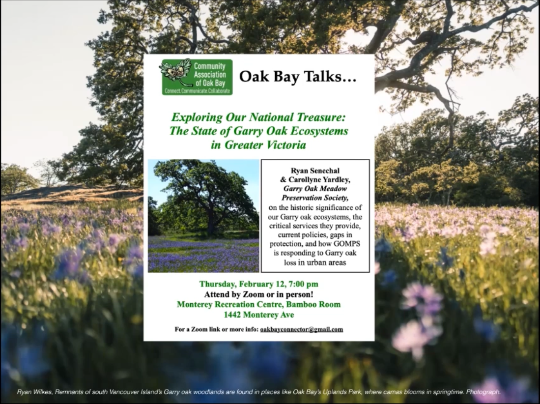
GOMPS – Community Association of Oak Bay. Thursday, February 12, 2026, at 7:00 pm. Zoom and in person. Monterey Recreation Centre, Bamboo Room. Oak Bay Talks presents: Exploring Our National Treasure: The State of the Garry Oak Ecosystems in Greater Victoria. Ryan Senechal and Carollyne Yardley, Garry Oak Meadow Preservation Society, on the historic significance of the Garry oak ecosystems, the critical services they provide, current policies, gaps in protection, and how GOMPS is responding to Garry oak loss in urban areas. Links Community Association of Oak Bay https://www.oakbaycommunityassociation.org Garry Oak Meadow Preservation Society https://www.garryoak.info
Front page
-
A Nanaimo trail project reveals how B.C. fails to protect rare ecosystems

Trail construction in Nanaimo, B.C., dug up a rare slimleaf onion patch, exposing the lack of protection for endangered Garry oak ecosystems
March 3, 2026
 9 min. read
https://thenarwhal.ca/nanaimo-slimleaf-onion-disturbed/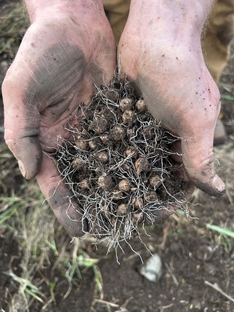
Residents in Nanaimo, B.C., became concerned when they realized that rare — and tiny — slimleaf onion bulbs were dug up to build a new trail. Photos: Supplied by Hunter Jarratt
Michael Geselbracht was out for a Saturday run in Nanaimo, B.C., when he came across soil piled up in a special area he knew was part of a native Garry oak ecosystem.
That particular spot — across from a row of houses on View Street, parallel to a railway — had been an improbably dense and thriving meadow of a native plant called slimleaf onion. The patch was something of a terrestrial island, approximately 50 square metres surrounded by introduced grasses and weeds. Still, the onions persisted. They had given an especially impressive show of white and the rarer pink flowers in the last wet spring.
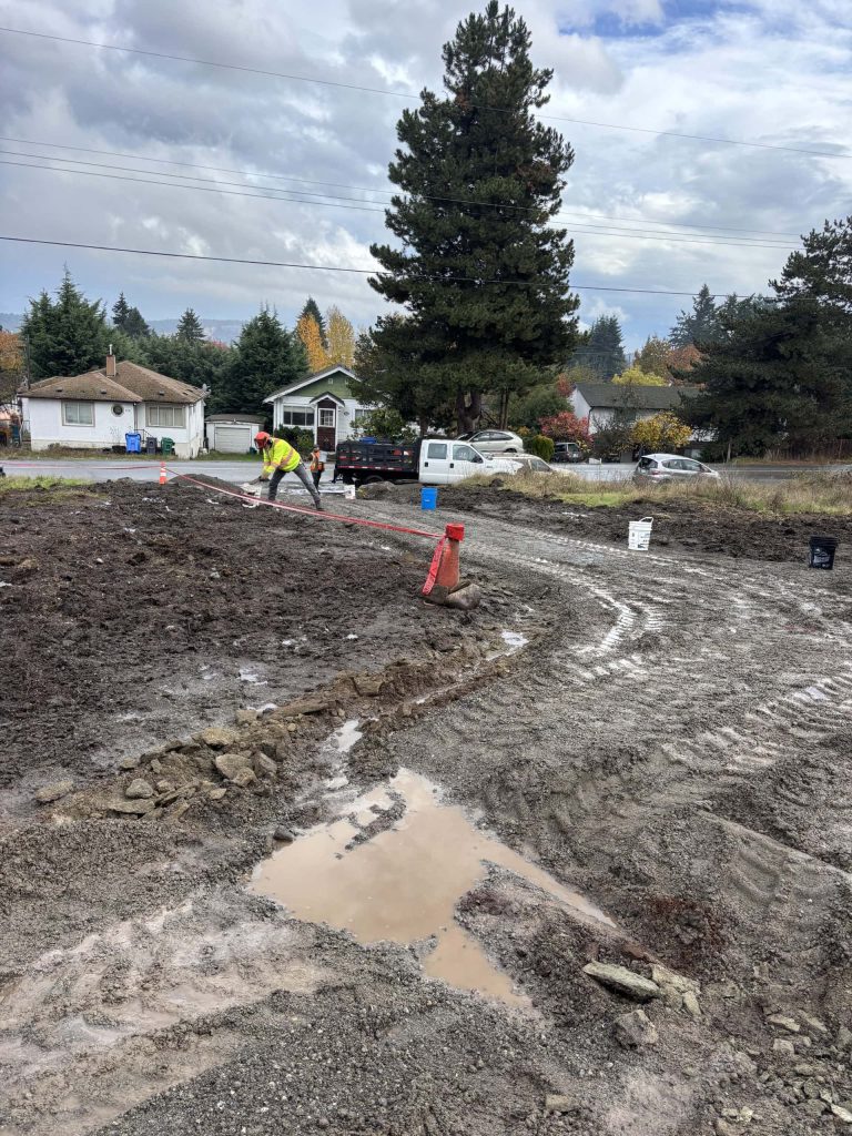
But in October 2025, thousands of nickel-sized bulbs were turned up by heavy machines and strewn like pebbles across the soil’s surface when the meadow became a construction site. The transformation was part of an effort to develop a multi-use trail corridor along the railway route by a group called the Island Corridor Foundation — a trail that, unbeknownst even to many local conservationists, routed through the rare patch of slimleaf onions.
Slimleaf onion is a blue-listed species in B.C., designated of “special concern, vulnerable to extirpation or extinction.” But it’s also just one of more than 100 plants and animals on the province’s species-at-risk list in the critically endangered Garry oak ecosystem it belongs to.
The biodiverse and fire-adapted Garry oak ecosystem has been tended by Indigenous Peoples for thousands of years. But after 150 years of settlement, less than five per cent of the Garry oak ecosystem remains in a near-natural state. Some also hang on in remnants like the one on View Street, adulterated by invasive plants, mostly forgotten, hard to spot out of season, disconnected from other Garry oak plant communities and, more often than not, totally legal to destroy.
‘No Garry oak ecosystem that has been unimpacted’Geselbracht spends most days outside teaching kids to love the natural world in the Nanaimo Forest School. He’s helped restore the local Cat Stream for salmon, and has spent more than 70 hours pulling invasive plants like trailing blackberry and English ivy from his neighbourhood.
Like many Nanaimo residents, he was thrilled with the prospect of more trails — for cycling and for access to more community projects, like the food forest he helped clear from a weedy abandoned lot. It all seemed worth a bit of mud and machines.
“It’s the connectivity, you know — the more that we have these connected trails, the more people start to use them,” Geselbracht says.
But he hadn’t expected the route to go through the native plants; he knew something should be done. So he spread the word and texted pictures of the bulldozed area to others in Nanaimo. Some people salvaged bulbs — a pair of cupped hands can hold more than 50. A biologist living in the neighbourhood stopped by with specific suggestions to prevent further harm. The Nanaimo Area Land Trust sent a letter to the city, imploring them to mitigate the damage. “Even when there’s this tiny remnant, you just feel the loss of it, in terms of death by a thousand cuts,” Linda Brooymans, stewardship manager for the land trust, told The Narwhal.
Since the City and the Island Corridor Foundation were alerted to the presence of the onion, workers have put in small culverts to direct water to the remaining bulbs — the plants rely on seasonal wetlands called vernal pools. They also replaced the soil, laid straw in an effort to protect the site and built a fence to protect the area from foot traffic. By January some of the bulbs were sprouting.But native plant advocate Hunter Jarratt says the fence caused further disruption and, positioned at the back of the patch, won’t do anything to keep people from walking on the plants. Jarratt knew that spot for the rare slimleaf onion and was shocked to find it scraped to bedrock.
Only the spring will tell if the ground will hold water like it did before, how many of the plants will survive and whether the straw or site disturbance will result in a weed boom. No matter what, Jarratt says the slimleaf onion population will never again be what it was in numbers or genetic diversity.
“It was beautiful, and it’s all gone. And what was the reason, you know?”
At the heart of the ecosystem disappearing act is a simple conflict — the inviting flower-filled meadows occur where people want to live. Fire suppression, aggressive invasive plants and the impact of off-road vehicles adds to the threat.
But there is little legal protection for Garry oak ecosystem remnants — and plants like slimleaf onion often fall through the cracks.

Slimleaf onion isn’t protected under the Species At Risk Act, leaving most habitat in B.C. subject to patchwork rules and largely voluntary protection. Photo: Supplied by Thomas Bevan No environmental assessment needed for trail construction
Advocates worry the slimleaf onion, though rare, is not meaningfully protected by any level of government.
Locally, the City of Nanaimo has bylaws protecting trees, like the Garry oaks themselves, and has included known ecosystems for plants like slimleaf onion in environmentally sensitive zoning, which triggers extra requirements like professional assessment and protection during development. Some municipal ecosystems are protected from development by park areas like Nanaimo’s Lotus Pinnatus Park or Victoria’s Beacon Hill Park.
Provincial legislation includes mandates for threatened plant species — but only applies within specified areas, like designated ecological reserves or in public forests (Crown land). The often-narrow parameters for designating protection can also lag behind — for example, the Forest and Range Practices Act hasn’t updated its list of protected plants since 2006. In any case, none of the existing provincial rules would apply to the View Street slimleaf onion.
Neither is slimleaf onion on the list of plants recognized by the federal Species At Risk Act. The plant could potentially benefit tangentially from an ecosystem recovery plan created for five other Garry oak ecosystem plants, though that plan is only automatically enforceable on federal lands — that’s just four per cent of Canada and around one per cent of land in B.C. On private land in B.C.— such as the rail corridor — enforcement is voluntary. On public land, there is “piecemeal legislation” and “non-legal recommendations and guidance,” according to a 2022 audit.
The federal government has the power under the Species At Risk Act to make emergency protection orders, but rarely does.
When City of Nanaimo councillors unanimously approved the path extension in July of 2025, none of the laws protecting species at risk applied. And at just over 700 metres of gravel path, the Island Corridor Foundation project — on private land and not zoned as environmentally sensitive — didn’t require a permit or an environmental assessment.
Charlotte Davis, Nanaimo’s Parks and Natural Areas deputy director, says the small area wasn’t zoned for protection because it wasn’t found during the last assessment — but she’s hopeful imaging advancements will make it easier to find small areas like these in the next one, as early as 2028.Davis also notes the project has increased access to safe trail for locals but that more engagement before construction “would have allowed us to be more aligned with the local naturalist community, with whom we share so many values, from the outset.”
The plant advocates want to protect the slimleaf onion — and other rare plants — even when they grow outside legislated or bylawed protection areas, like the View Street meadow.
“It wasn’t perfect, but there’s no Garry oak ecosystem that has been unimpacted. This is the best we have left,” Jarratt says.
“How do we control [the disturbance of native ecosystems] if we don’t even have them mapped, or we don’t even know where they are?” he asks.
But B.C.’s Garry oak ecosystem hasn’t been comprehensively mapped since 1993. The last analysis, noting only five per cent of the ecosystem remaining, came from a 2006 study.With population growth and urban development, advocates say that measurement has changed in the last 20 years.
There are proposed projects in known Garry Ook ecosystem around Nanaimo; residential and industrial development in Cable Bay, nearly 200,000-square-foot data centre on East Wellington Road, housing in Linley Valley and a new subdivision in Harewood Plains — city council has asked provincial and federal governments for help protecting the latter.
Nanaimo zoning bylaws require developers to take extra measures in noted sensitive areas but don’t prohibit new construction.
What is harder to measure are the unmapped survivors on private land — they can be legally built over, perhaps without anyone knowing they were there. “There’s just examples of this kind of stuff happening all the time, everywhere,” Jarratt says.
Vancouver Island railway project hopes to promote sustainability and recreation
The Nanaimo trail expansion is one small part of a larger vision for Vancouver Island’s rail corridor.
The railway was originally built in the late 1800s by British Columbia’s coal king, Robert Dunsmuir on 800,000 hectares of Coast Salish, Nuu-Chah-Nulth and Kwakwa̱ka̱ʼwakw land. But by the early 2000s, the railway was faltering and the Island Corridor Foundation was formed to keep the corridor intact.
“We are the little railway that could,” Island Corridor Foundation Chief Executive Officer Thomas Bevan says. A team of just four people, including himself, manage nearly 300 kilometres of rail corridor on Vancouver Island.
The foundation has a vision for sustainable transportation — passenger and freight rail service, alongside walking and cycling paths. Considering environmental and financial concerns as well as the interests of Indigenous groups and diverse local stakeholders — such as native plant advocates — is fraught. As Bevan puts it, nobody’s going to get everything they want.Still, environmental concerns figure strongly in the foundation’s mandate, and Bevan says they do what they can, like the $600,000 the group spent clearing invasive Scotch broom and blackberry along 125 kilometres of rail corridor, from Victoria to Qualicum Beach, B.C., in 2024 and 2025. Bevan says they are looking for funding to deal with the regrowth and other areas of the corridor.
Finding out too late
If there had been a voluntary environmental assessment of the trail expansion in Nanaimo, a qualified biologist would have done a survey, perhaps even checked the iNaturalist database where multiple slimleaf onion and other Garry oak plants were logged on View Street. They would have established a baseline for the existing population and potentially found other threatened species. They may have recommended shifting or narrowing the course of the path to avoid the most sensitive habitat.
Instead, Bevan found out about the slimleaf onion after the fact, and says, as someone who follows Jarratt’s native plant advocacy, he felt awful.
Going forward, Bevan says the Island Corridor Foundation will work on new policy for sensitive areas and has allocated $10,000 for restoration efforts — potentially weeding or reintroducing native plants. They are seeking a community partner to execute the work.
Geselbracht, the forest school teacher, imagines a future where all the neighbours know more about the Garry oak ecosystem plants and remnants in their backyard, and help to bolster them — like he wishes he had done sooner.
For four years Geselbracht has been tending Garry oak seedlings with hopes to eventually reintroduce them in the View Street native plant patch, with his students. “If I’d had them doing some planting then maybe, on their walk to school, when they saw the excavator there, they would have said something.”
-
Garry Oak species classification within urban forest canopy analysis: a collaboration between GOMPS, UBC’s Master of Geomatics For Environmental Management, and Terra Remote Sensing
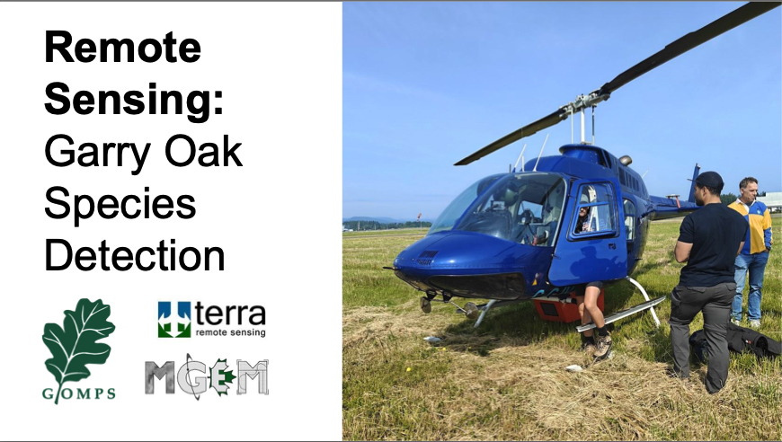
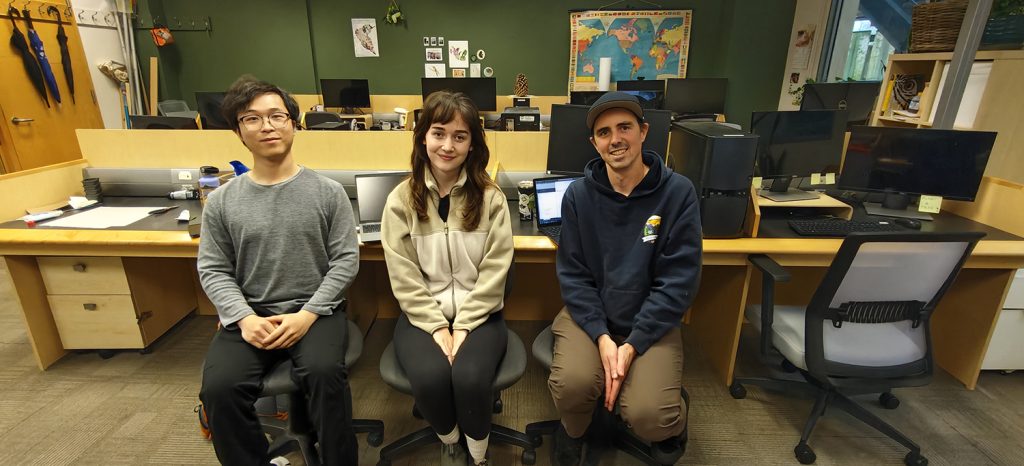
Ryan Senechal with Kate and Jason, MGEM Program, and at the UBC urban forest research hub. Nov 6, 2025. Garry Oak species classification within urban forest canopy analysis: a collaboration between GOMPS, UBC’s Master of Geomatics For Environmental Management, and Terra Remote Sensing
Project Origins
Garry Oak Meadow Preservation Society has set out to develop a new approach to urban forest monitoring using remote sensing technologies. The Greater Victoria Area is situated in some of the highest remaining concentrations of Garry oak trees and Garry oak and associated ecosystems, and the critically endangered Garry oak ecosystem is facing intensifying land use development pressure. Measuring change in historic Garry oak ecosystem presence and the sharp decline of its extent over time was captured in Historical Garry oak ecosystems of Vancouver Island, British Columbia, pre-European contact to the present (Ted Lea, 2006), but at a very large scale that presents challenges to interpret and apply at the local scale to understand Garry oak ecosystem health and extent.
Garry Oak Mapping in the Capital Region
Garry oak-specific mapping has not been updated since the production of Ted Lea’s 2006 publication, but urban forest canopy measuring and monitoring has gradually come online thanks to early efforts spearheaded by Habitat Acquisition Trust to measure land cover classification at the regional scale, and later with multiple local governments adopting urban tree canopy analysis within the Capital Regional District. GOMPS identified a gap in urban forest measuring approach and recognized that providing Garry oak-specific analysis would inform better overall urban forest decision making and outcomes.Fielding Interest and Research
In 2023, GOMPS began exploring the body of research on remote sensing approaches to classify individual tree species, and consulted with experts in remote sensing in academic, non-profit, government, and commercial organizations to develop a project scope with the greatest potential for accuracy, repeatability, and ultimately adoption by local government urban forest managers. We learned that while species classification was a capacity that was growing in commercial forestry applications, it remained largely absent from urban forest canopy analysis, and Garry oak species classification had not been conducted in academic or commercial applications. Recognizing the importance of a high-accuracy Garry oak-specific lens to support better urban forest stewardship decision making across the region, there was awareness that GOMPS would be the ideal organization to fundraise, activate, and lead the research and development of this tool.Study Area
The study area selected was City of Victoria and a portion of District of Saanich defined as the urban containment boundary. The area selected was targeted intentionally for several purposes, including the strength of existing urban forest management policies and availability of existing urban forest analysis products, for example, a public tree inventory (City of Victoria), and multiple years of urban forest canopy analysis using LiDAR (City of Victoria, District of Saanich). Both City of Victoria and District of Saanich had the greatest commitment and available resources to conduct ongoing measuring and monitoring of the urban forest, and are facing enormous urban development pressure with Provincial legislation adopted in 2023 (e.g., the Housing Supply Act, Housing Statutes (Residential Development) Amendment Act, etc.). Both communities have urban forests which are situated disproportionately on private property (e.g., 75% of City of Victoria’s and 72% of District of Saanich’s urban forest are on private lands), indicating high exposure of Garry oak loss to private land use development and low capacity for those communities to offset those losses on public property. GOMPS’ narrowed the survey for this initial proof of concept project based on the high cost of imagery/LiDAR acquisition with hopes that this project can be replicated in the near future to incorporate other municipalities in the Capital Regional District and beyond.Project Launch
Shortly after the Board’s approval of the project in late 2024 and GOMPS receiving a generous donation to enable the acquisition of aerial imagery/LiDAR, a remote sensing contractor was selected in late 2024 who satisfied the technical capacity required for the project. Shortly before the flight to acquire the raw imagery and LiDAR of the study area, news of our official connection to UBC’s MGEM program came with two students (Kate McIntyre and Jason Wu) being assigned to the research and development of the species classification tool for their capstone projects. The project technical capacity within GOMPS is provided by its Board President, Ryan Senechal, an urban forest professional and educator based in Saanich. Ryan’s work as Lecturer of Urban Forestry at UBC’s Faculty of Forestry connected him globally to urban forest remote sensing research and case study, and to researchers and experts in environmental geomatics within the Faculty.Data Acquisition
Terra Remote Sensing based in Sidney, BC, contracted two flights at 900 m flight level midday in late June of 2025 near the summer equinox, and this timing was intended to capture Garry oaks in full early summer foliage while minimizing shadows on aerial imagery due to sun angle during flights. Technical specifications of the data acquired include 4 band (RGB, NIR) orthographic imagery at 10 cm resolution, and 2 mhz pulse rate LiDAR at 45 points/m2 point cloud density and a scan angle of 60 degrees (30 degrees per side). The reason we chose to acquire raw data using preferred timing and resolution was to provide ideal data quality to perform software analysis and achieve the highest possible accuracy of the tool that is delivered at completion of the project. Previously flown and acquired datasets are more cost effective but may not be ideally timed or provide the specifications we desired, for example, the near infrared spectrum of aerial imagery, which is likely to play an important role in the accuracy of species classification in the analysis phase.Data Analysis
The project has entered the analysis stage starting with Terra Remote Sensing’s initial data cleaning, pre-classification tree height at minimum 2 m height, and an urban forest canopy analysis incorporating all species. Kate and Jason from UBC’s MGEM program have been busy in their graduate course work developing knowledge and skills with geospatial, LiDAR and multi-spectral analysis and have been participating in occasional workshops with Terra Remote Sensing’s technical team. The development of species classification will be completed in mid-2026 and GOMPS is excited to circulate these datasets through our website and to partner organizations and governments following accuracy assessments at the completion of this project.
Open Source Information
This project incorporates community open access as a key priority, including the distribution of our project scope and methods, datasets, key findings, and limitations. We are pleased to support Indigenous governments, organizations and governments, researchers and non-profit organizations with our obtained LiDAR and ortho products by request. For access to dataset requests and other project inquiries, please contact us.
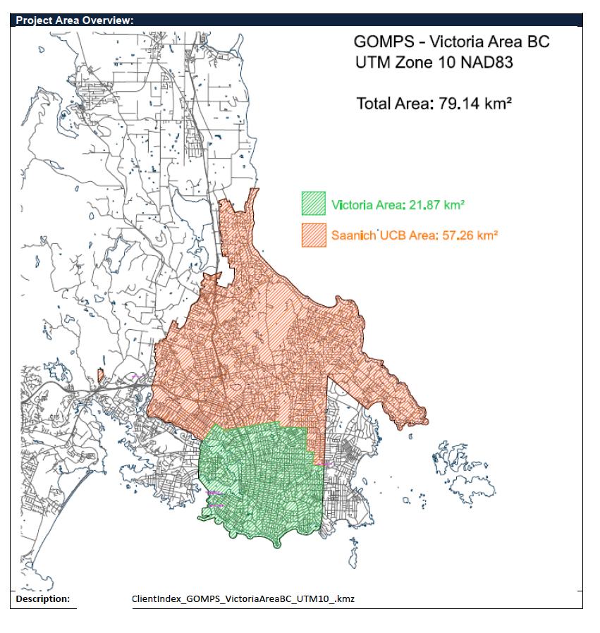
Map by Terra Remote Sensing. Victoria Area: 21.87 km2 and Saanich UCB Area: 57.26km2 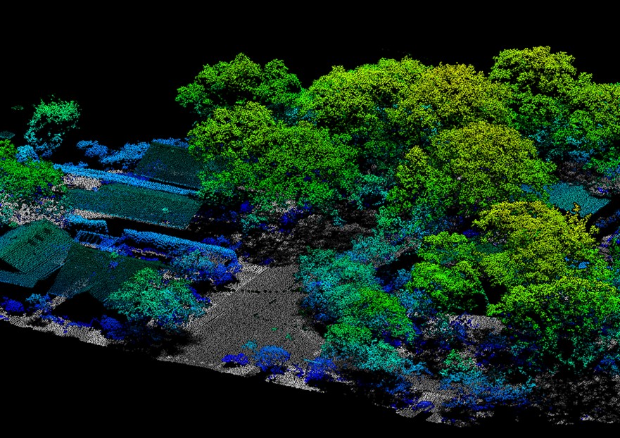
-
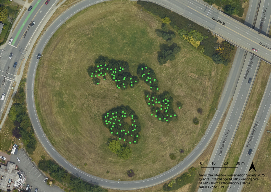
The Quadra Overpass Garry Oak Planting: 30 Year Remeasurement, Sept 2025.
By Jacklyn Jolicoeur and Ryan Senechal
The Commonwealth Games Legacy Garry Oaks
This was a legacy Garry oak tree planting project to commemorate the 1994 Commonwealth Games. Two members of GOMPS -Jean-Anne Whitman, landscape architect and Willie MacGillivray, together with the Ministry of Transportation and Highways, the Provincial Capital Commission, Forestry Canada and a group of community volunteers, participated in this project.
Planting Technique and Seedling Source
All of the planting techniques were arrived at through consultation with representatives of GOMPS, Forestry Canada and a project manager, Ms. Carol Jones, Professional Agrologist and Nursery operator in North Saanich at the time. The intent was to use “the planting project to assess the growth and health of Garry oak seedlings and to evaluate the use of seedling protection tubes.”The site preparation included stripping, burying, and tilling the sod, blanketing the site with landscape cloth, and then covering it with bark mulch to keep weeds back. As such, the site approximates a near-natural, non-irrigated habitat.
The Garry oak seedlings were “plugs” grown the year before (1993) by Rob Hagel of the Pacific Forestry Centre. On February 19, 1994, volunteers planted 211 seedlings by inserting them into holes dug through the mulch and cloth with a tablet of Bestgro fertilizer placed into the bottom of each hole. Approximately 80% of the seedlings were shielded with protective tubes.
Photo by Jacklyn Jolicoeur. The remains of an original protective tube can be seen at the base of the tree Previous Inspections
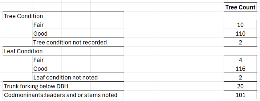
The planting clusters were inspected during March of 1994, April of 1995, and in October 1995. The writers do not have access to the records for these inspections. In the fall of 2005, Dr Michael Meagher (retired forester and honorary member of GOMPS) recorded some key measurements and statistics for the planting clusters in the GOMPS newsletter (June 2006), which form the basis of a comparison of the Garry oak trees in 2005 and 2025 (see table below).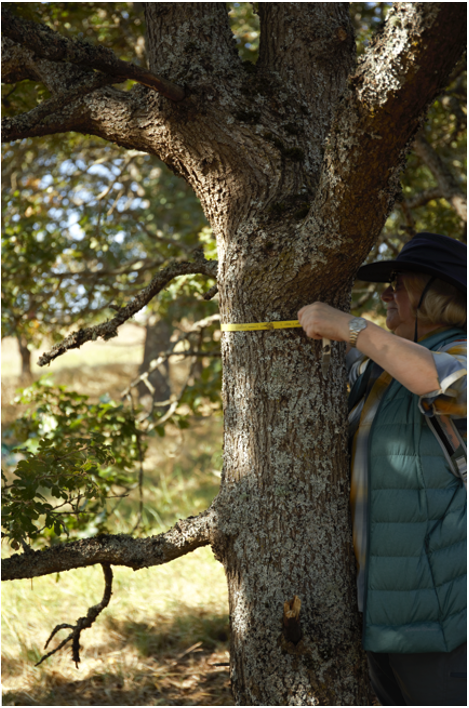
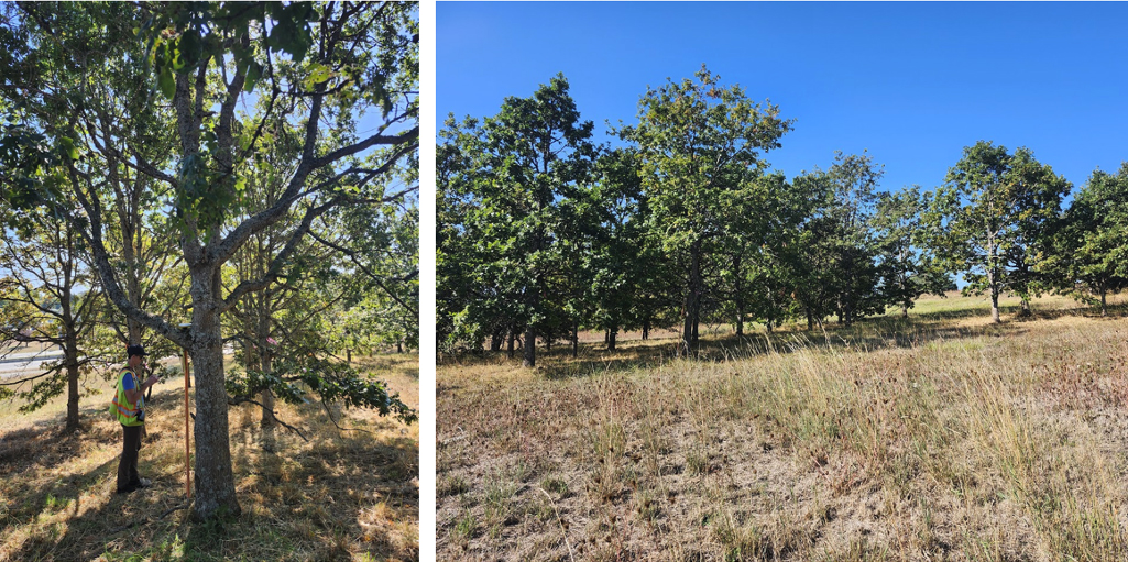
Jacklyn is measuring the DBH – diameter at breast height. 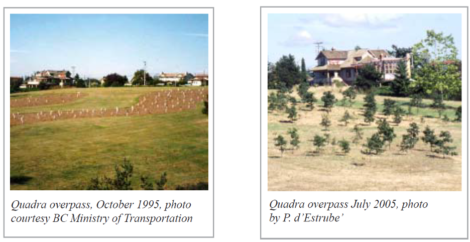
Quadra Overpass, September 2025, photo by Ryan Senechal.
The Bird of Paradise Pub (visible in previous 1995 and 2005 photos) is now obscured by the Garry oak trees that are now just over 30 years old.2025 Remeasurement
During September of 2025, two members of GOMPS (Ryan Senechal, President and Jacklyn Jolicoeur, Director visited the plantation site and recorded basic tree inventory statistics for all remaining survivors of the plantation into a mobile application. The tree data collected included the GPS coordinates, DBH (diameter at breast height), tree height, tree condition, leaf condition, and tree comments. Here is a comparison summary of the Garry oak tree data over the years.
Quadra Interchange Sept 3, 2025 Tree Inventory (.pdf)
Comparison data of Garry oak tree data:
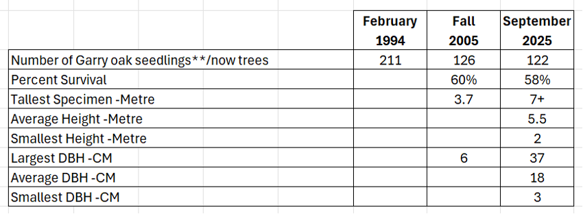
Data collected in 2025:

Quadra Overpass, September 2025, photo by Ryan Senechal.
The Bird of Paradise Pub (visible in previous 1995 and 2005 photos) is now obscured by the Garry oak trees that are now just over 30 years old.Some key takeaways from the assessment
- Garry oaks require some protection and establishment care to minimize plant mortality.
- Young tree mortality primarily occurred within the first 10 years of planting.
- Canopy growth and ring growth rates are slow but faster than estimated in 2006 article).
- Narrow spacing between Garry oak trees has a considerable effect on understory biodiversity. These Garry oaks were planted at approximately 3.5 to 4 metres apart. Optimum spacing would be 10 metres.
- Shrubs and herbaceous species were lacking in the understory. Multiple stick nests were present, but the species occupying those nests could not be identified.
- The trees were crowded and crowns overlapped.
- Acorn collection should take the Garry oak tree form into consideration. The majority of trees planted demonstrated similar branch architecture. One defect that consistently appeared was forks with included bark.
Future Opportunities – Short Term
- Resurrect a sign at the Quadra Interchange to acknowledge this legacy tree planting project
- Remeasurement of the McKenzie interchange that was also planted in 1994.
- Introduce stand management to address weak branch unions, improve tree spacing and enhance understory biodiversity.
Future Opportunities – Long Term
- Resurrect the vision for the Ministry of Transport (MOT) to improve the local highway landscape with interagency cooperation amongst local governments, GOMPS and others in the volunteer environmental community. This vision would pursue enhancement to the large linear greenway along highways with Garry oak tree/meadow plantings to promote biodiversity, climate adapted natural vegetation and create improved driving experience.
- Extend planting areas and incorporate companion species. Improve access from Quadra St and incorporate seating.
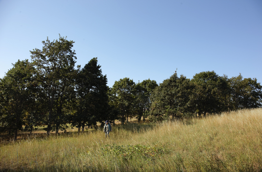
Quadra Overpass, September 2025, photos by Jacklyn Jolicoeur.
Left Picture: Ryan is recording tree data using the mobile app with a GPS locator (see orange pole on the left-hand side of the Garry oak tree).
Right Picture: The young Garry oak trees have an average height of just under 6 metres.Sources:
Jane Waters, Roadside Development Programs, Ministry of Highways and Transportation, “Ministry describes highway replanting program” Garry Oak Meadow Preservation Society Newsletter, Volume 2, Number 8, Page 4, September 1995.
Pierre d’Estrube, President GOMPS, “The Quadra Overpass Garry Oak Plantation” Garry Oak Meadow Preservation Society Newsletter, Volume 13, Number 1, Page 5, June 2006.
-
VCAN Garry Oak Community Mapping Project
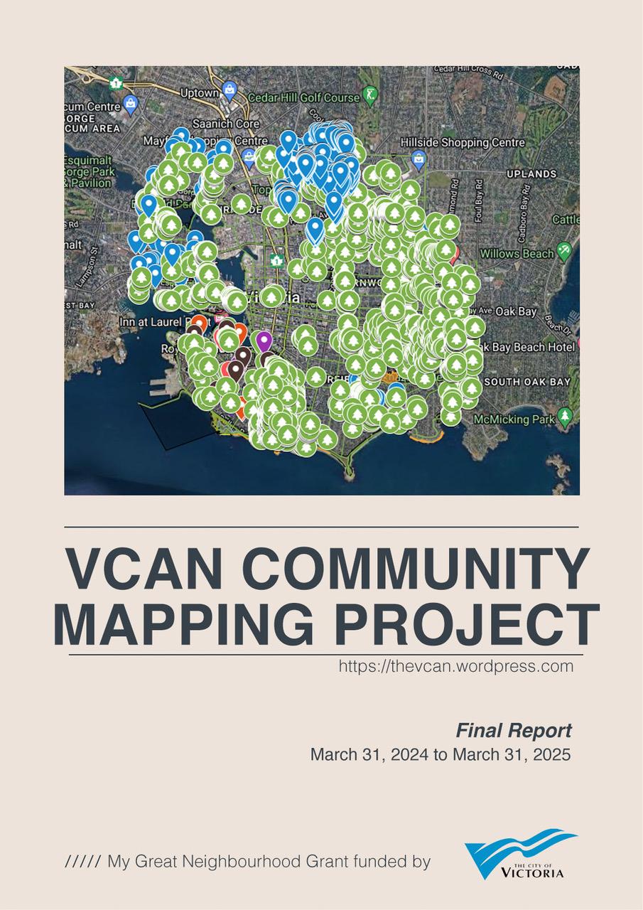
Final Report, Victoria Community Network Association Mapping Project (VCAN)
The Victoria Community Network Association Mapping Project (VCAN) was funded by the City of Victoria’s My Great Neighbourhood Grant (Resilience) program. Thank you to the VCAN Mapping Team for your time and significant contributions to the project. GOMPS provided a letter of support and urban forest expertise via a walking tour for participants.
From March 2024 to March 2025, the project aimed to assess biodiversity distribution within Victoria’s neighbourhoods on private property, complementing the city’s existing tree inventory on public land. The urban area of the City of Victoria is the Garry oak ecosystem (GOE)–– a fact often left out of discussions on the urban forest.
Project Objectives:
– Enhance awareness of cultural ties to the territory and the effects of settlement.
– Foster connections between residents and the urban natural environment.
– Develop a more complete map of Garry oaks and biodiversity elements.
– Identify wildlife corridors for organism movement between complex ecosystems.
– Assist in protecting and restoring the function of sensitive ecosystems and natural areas, including habitat corridors and assist with the parks acquisition strategy (9.2 of the Official Community Plan).
The project’s outcomes aim to inform ecological and cultural restoration, urban development, park acquisition, and canopy equity initiatives.
Phase 1 Highlights:
– Development of an interactive web map accessible and editable by community members.
– Creation of tutorials for mapping significant areas.
– Organization and conversion of data for analytical purposes.
– Preliminary habitat analysis for statistical assessment.
The VCAN Mapping Team also initiated a letter for discussions with builders and developers to address land use changes impacting the Garry oak ecosystem and consider planting native plants and trees as a tangible act of connecting with the territory.
This project serves as a catalyst for dialogue to foster cultural and ecosystem awareness, ultimately promoting a healthier urban canopy and ecosystem through collaborative efforts.
Final report:
VCAN Community Mapping Project (.pdf) (March 2025)
Project Documents
Zoom to enlarge areas on the map. The City of Victoria Garry oak tree inventory data is noted in green. Other points represent individual trees or areas where Garry oaks exist. Please note, this is not an individual Garry oak tree count and does not represent all Garry oak trees in the City of Victoria. Neighbourhoods participating in this community building project included Burnside Gorge, Downtown, Fairfield / Gonzales, Fernwood, Hillside Quadra, James Bay, North Jubilee, South Jubilee, North Park, Oaklands, Rockland, Victoria West.Presentation Slides
Presentation slides by Carollyne Yardley (.pdf) (Rockland Neighbourhood)
Printed slide deck at wrap-up event by Jacklyn Jolicoeur(.pdf) (James Bay Neighbourhood)Mapping Tutorials
VCAN Mapping Tutorial (.pdf) (Cedar Shore Consulting)
Ken Wong’s Organic Maps Tutorial (.pdf) (Hillside/Quadra)Preliminary Suitable Habitat Analysis
Preliminary statistical analysis of environmental characteristics at mapped Garry Oak Tree locations (.pdf) (Cedar Shore Consulting)Dear Developer: An Earthly Invitation template (.doc) (March 2025)
-
Annual General Meeting

Annual General Meeting
GOMPS 2023-24 AGM will be held:
DATE: Sunday, November 17, 2024
TIME: 3:00 to 5:00pm
LOCATION: Banquet Room, Cedar Hill Golf Course, 1400 Derby Rd, Saanich.Our meeting will include:
· Presentation of various reports – President, Nursery, Treasurer & Volunteer
· Election of officers, and
· An open discussion about Garry oak issues with focus on future directions
As per GOMPS bylaws, there are 7 board members’ positions including:
· President,
· Vice-President,
· Secretary,
· Treasurer, and
· 3 Directors at Large.
3 Director positions are up for election this year as 4 Directors continue in their 2-year terms and 1 Director becomes a Director Emeritus. Please consider joining our board or nominate someone for a board position by sending nominations to: Judith Carder (Secretary) at judeathome at shaw.ca by Friday, November 8th, 5:00 pm.
In order to vote at meetings and to run for election to the board, you must have a current GOMPS membership.
The opportunity to purchase or renew your membership will be available at the AGM (cash or cheque only, at this time).
Your attendance and input during the discussion period at our meeting will be greatly welcomed and appreciated!