admin

  • Garry Oak species classification within urban forest canopy analysis: a collaboration between GOMPS, UBC’s Master of Geomatics For Environmental Management, and Terra Remote Sensing

    Ryan Senechal with Kate and Jason, MGEM Program, and at the UBC urban forest research hub. Nov 6, 2025.

    Garry Oak species classification within urban forest canopy analysis: a collaboration between GOMPS, UBC’s Master of Geomatics For Environmental Management, and Terra Remote Sensing

    Project Origins
    Garry Oak Meadow Preservation Society has set out to develop a new approach to urban forest monitoring using remote sensing technologies. The Greater Victoria Area is situated in some of the highest remaining concentrations of Garry oak trees and Garry oak and associated ecosystems, and the critically endangered Garry oak ecosystem is facing intensifying land use development pressure. Measuring change in historic Garry oak ecosystem presence and the sharp decline of its extent over time was captured in Historical Garry oak ecosystems of Vancouver Island, British Columbia, pre-European contact to the present (Ted Lea, 2006), but at a very large scale that presents challenges to interpret and apply at the local scale to understand Garry oak ecosystem health and extent. 


    Garry Oak Mapping in the Capital Region
    Garry oak-specific mapping has not been updated since the production of Ted Lea’s 2006 publication, but urban forest canopy measuring and monitoring has gradually come online thanks to early efforts spearheaded by Habitat Acquisition Trust to measure land cover classification at the regional scale, and later with multiple local governments adopting urban tree canopy analysis within the Capital Regional District. GOMPS identified a gap in urban forest measuring approach and recognized that providing Garry oak-specific analysis would inform better overall urban forest decision making and outcomes. 

    Fielding Interest and Research
    In 2023, GOMPS began exploring the body of research on remote sensing approaches to classify individual tree species, and consulted with experts in remote sensing in academic, non-profit, government, and commercial organizations to develop a project scope with the greatest potential for accuracy, repeatability, and ultimately adoption by local government urban forest managers. We learned that while species classification was a capacity that was growing in commercial forestry applications, it remained largely absent from urban forest canopy analysis, and Garry oak species classification had not been conducted in academic or commercial applications. Recognizing the importance of a high-accuracy Garry oak-specific lens to support better urban forest stewardship decision making across the region, there was awareness that GOMPS would be the ideal organization to fundraise, activate, and lead the research and development of this tool. 
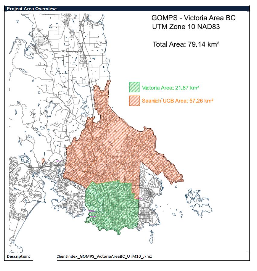
    Study Area
    The study area selected was City of Victoria and a portion of District of Saanich defined as the urban containment boundary. The area selected was targeted intentionally for several purposes, including the strength of existing urban forest management policies and availability of existing urban forest analysis products, for example, a public tree inventory (City of Victoria), and multiple years of urban forest canopy analysis using LiDAR (City of Victoria, District of Saanich). Both City of Victoria and District of Saanich had the greatest commitment and available resources to conduct ongoing measuring and monitoring of the urban forest, and are facing enormous urban development pressure with Provincial legislation adopted in 2023 (e.g., the Housing Supply Act, Housing Statutes (Residential Development) Amendment Act, etc.). Both communities have urban forests which are situated disproportionately on private property (e.g., 75% of City of Victoria’s and 72% of District of Saanich’s urban forest are on private lands), indicating high exposure of Garry oak loss to private land use development and low capacity for those communities to offset those losses on public property. GOMPS’ narrowed the survey for this initial proof of concept project based on the high cost of imagery/LiDAR acquisition with hopes that this project can be replicated in the near future to incorporate other municipalities in the Capital Regional District and beyond.

    Project Launch
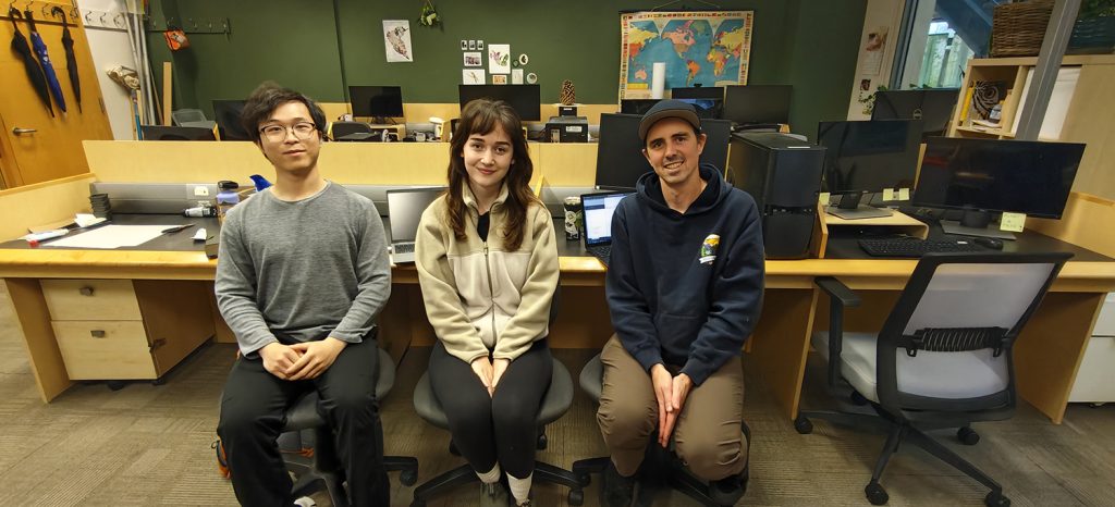
    Shortly after the Board’s approval of the project in late 2024 and GOMPS receiving a generous donation to enable the acquisition of aerial imagery/LiDAR, a remote sensing contractor was selected in late 2024 who satisfied the technical capacity required for the project. Shortly before the flight to acquire the raw imagery and LiDAR of the study area, news of our official connection to UBC’s MGEM program came with two students (Kate McIntyre and Jason Wu) being assigned to the research and development of the species classification tool for their capstone projects. The project technical capacity within GOMPS is provided by its Board President, Ryan Senechal, an urban forest professional and educator based in Saanich. Ryan’s work as Lecturer of Urban Forestry at UBC’s Faculty of Forestry connected him globally to urban forest remote sensing research and case study, and to researchers and experts in environmental geomatics within the Faculty. 
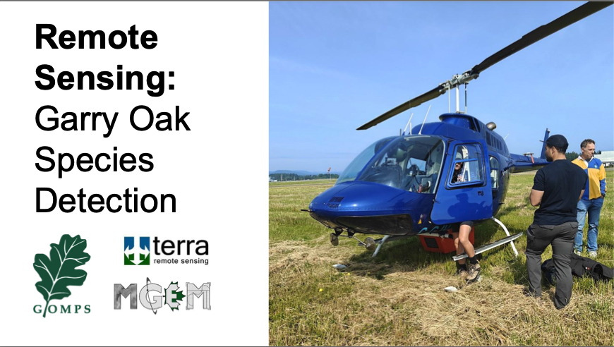
    Data Acquisition
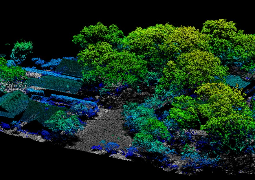
    Terra Remote Sensing based in Sidney, BC, contracted two flights at 900 m flight level midday in late June of 2025 near the summer equinox, and this timing was intended to capture Garry oaks in full early summer foliage while minimizing shadows on aerial imagery due to sun angle during flights. Technical specifications of the data acquired include 4 band (RGB, NIR) orthographic imagery at 10 cm resolution, and 2 mhz pulse rate LiDAR at 45 points/m2 point cloud density and a scan angle of 60 degrees (30 degrees per side). The reason we chose to acquire raw data using preferred timing and resolution was to provide ideal data quality to perform software analysis and achieve the highest possible accuracy of the tool that is delivered at completion of the project. Previously flown and acquired datasets are more cost effective but may not be ideally timed or provide the specifications we desired, for example, the near infrared spectrum of aerial imagery, which is likely to play an important role in the accuracy of species classification in the analysis phase.  

    Data Analysis
    The project has entered the analysis stage starting with Terra Remote Sensing’s initial data cleaning, pre-classification tree height at minimum 2 m height, and an urban forest canopy analysis incorporating all species. Kate and Jason from UBC’s MGEM program have been busy in their graduate course work developing knowledge and skills with geospatial, LiDAR and multi-spectral analysis and have been participating in occasional workshops with Terra Remote Sensing’s technical team. The development of species classification will be completed in mid-2026 and GOMPS is excited to circulate these datasets through our website and to partner organizations and governments following accuracy assessments at the completion of this project.


    Open Source Information
    This project incorporates community open access as a key priority, including the distribution of our project scope and methods, datasets, key findings, and limitations. We are pleased to support Indigenous governments, organizations and governments, researchers and non-profit organizations with our obtained LiDAR and ortho products by request. For access to dataset requests and other project inquiries, please contact us.


    Watch video of flight day

    Map by Terra Remote Sensing. Victoria Area: 21.87 km2 and Saanich UCB Area: 57.26km2

  • GOMPS. “Letter to Oak Bay Municipality Council,” Agenda Item #7.3, Uplands Siting and Design (ADP00192) 2830-2850 Lansdowne Road, Nov 24, 2024.

    Garry Oak Meadow Preservation Society. “Letter to Oak Bay Municipality Council,” Nov 24, 2024. Agenda Item #7.3, Uplands Siting and Design (ADP00192) 2830-2850 Lansdowne Road.

  • Jeff Bell. Donated acorns help society produce Garry oak crop, Times Colonist. Oct 26, 2025.

    Times Colonist. Donated acorns help society produce Garry oak crop. Oct 2025.
    https://www.timescolonist.com/life/donated-acorns-help-society-produce-garry-oak-crop-11390955
    jbell@timescolonist.com

    A $13,000 grant from the Victoria Foundation to help preserve the trees in the group’s nursery is a major boost

    Acorns collected by the public are being planted to produce more Garry oaks as proponents work to strengthen the depleted tree species.

    Arborist and society president of the Garry Oak Meadow Preservation Society Ryan Senechal said a $13,000 grant from the Victoria Foundation to help preserve the trees in the group’s nursery is a major boost.

    The nursery is on Capital Regional District-owned land off the Pat Bay Highway just north of Sayward Road, and it has now been able to purchase a shelter where volunteers can work on the plants, Senechal said.

    The site used to be the location of the City of Victoria’s tree nursery, he said, so the group entered into a partnership with the city to take over the use of the property.

    Getting enough acorns to plant is “a community participatory project” that sees the society reaching out via its website, local media and social media for acorn donations, Senechal said.

    He said the society has been “overwhelmed” with the amount of acorns gathered this year, so no more are needed for now.

    The trees that can grow are from acorns that were “100 per cent” provided by community members, Senechal said.

    That fits with the society’s focus on producing the “local ecotype” of Garry oaks to distribute around the region, he said, and added the society is “interested in stewarding the local population.”

    The annual request for acorn donations comes in early September.

    Guidelines for the public include testing the acorns to see if they float, since acorns that float can’t be used.

    Also unsuitable are acorns with caps, which indicate that they aren’t ripe.

    Senechal said many of the acorns received have already started root growth, and some will emerge at the potting stage, while some will not.

    Once planted, the successful acorns take root and establish a small stem and leaves.

    He pointed to a 2006 study on Garry oak ecosystems that looked at their historical range on Vancouver Island and beyond, with the conclusion being that less than five per cent of the original range remained in Canada.

    That number refers to areas that are “relatively intact,” and it falls to three per cent for areas in prime condition, he said — making Canada’s Garry oak ecosystems “critically endangered.”

    Senchal said the Garry Oak Meadow Preservation Society was formed in 1992, a time when there was little in the way of tree-protection bylaws to manage urban forests.

    Its society members spent considerable time advocating for the sort of protections we see more of today.

    He said the “latest dilemma” for the society is the continuing fragmentation of remaining Garry oak ecosystems, and trees that are vulnerable due to the push for added space for housing in the region.

    This leaves them having to “constantly evolve as an advocacy organization.”

    The society website is at garryoak.info.

  • Summer/Fall (September) 2025 Newsletter

    Garry Oak Leaflet Summer/Fall 2025 (PDF)

  • Community Event / Spring Lecture: The Urban Forest in Saanich – Strategy and Stewardship

    The Camosun Community Associations presents a free lecture in partnership with the Mount Tolmie Community Association, featuring guest speaker, Ryan Senechal.
    Ryan Senechal is an educator and a practicing consulting arborist/ urban forester with experience across municipal, commercial, education and nonprofit sectors. He is a lecturer in the Bachelor of Urban Forestry and Master of Urban Forestry Leadership programs at University of British Columbia’s Faculty of Forestry. 

    Speaker: Ryan Senechal
    When: Wednesday, May 7th
    Time: Doors open at 6:45 pm – Lecture 7-9 pm – includes Q&A
    Where: Broad View United Church – 3703 St. Aidan’s St. (enter at lower level at back of church)Cookies, coffee and tea will be provided.
    You may read online about Ryan to get a notion of what keeps him active locally using these links:

    Spring Lecture: "The Urban Forest in Saanich: Strategy & Stewardship"
  • Spring (April) 2025 Newsletter

    Garry Oak Leaflet Spring 2025 (PDF)

  • Winter (Feb) 2025 Newsletter

    Garry Oak Leaflet Winter 2025 (PDF)

  • Ryan Senechal. Remote Sensing: Garry Oak Species Detection Project, GOMPS AGM, Nov 2024.


    The Remote Sensing: Garry Oak Species Detection Project is scheduled for June 2025.

    Garry Oak Meadow Preservation Society is a volunteer-run non-profit based in Saanich, BC providing advocacy functions around individual Garry oak and Garry oak ecosystem protection and stewardship. Mapping and analysis of the overall Garry oak ecosystem and individual trees in the Capital Regional District is out of date and utilizes methods that prevent cost-effective updates and efficient temporal analysis. Our interest is in developing a new approach to mapping Garry oak species presence using LiDAR and geoAI. By conducting species specific detection analysis to form a species composition baseline, we can enable future analysis opportunities that are Garry oak specific. 

    The Garry Oak Meadow Preservation Society (GOMPS) has partnered with Terra Remote Sensing, a geospatial data acquisition company, for an upcoming project. GOMPS is in interested in developing a new approach to map Garry oak species presence using LiDAR and machine learning. By conducting species specific detection analysis to form a species composition baseline, we can enable future analysis opportunities that are Garry oak and Garry oak ecosystem specific. This is an important contribution to a growing body of regional urban forest mapping that could influence changes in tree protection policies (e.g., enhanced existing tree protections and requirements for Garry oak replacement trees through private development), and management and planning for Garry oaks on public property.

    GOMPS initial analysis goals are to perform Garry oak species detection within two municipalities (City of Victoria, and District of Saanich’s Urban Containment Boundary), and eventually expand the method to survey all municipalities in the Capital Regional District. GOMPS hopes to have located and calculated the overall Garry oak canopy area. The goal is to offer the Garry oak mapping and high-resolution raw LiDAR/ortho data flown for this project publicly. This data sharing will support researchers, community members and other nonprofit organizations with our Garry oak species analysis, and also enable additional novel data analysis approaches supporting Garry oaks and Garry oak ecosystems. LiDAR Species Detection flight window is set for the week of June 23, 2025.

    Presentation Slides:

    presentationlidar.pdf

  • VCAN Garry Oak Community Mapping Project

    VCAN Garry Oak Community Mapping Project

    Final Report, Victoria Community Network Association Mapping Project (VCAN) 

    The Victoria Community Network Association Mapping Project (VCAN) was funded by the City of Victoria’s My Great Neighbourhood Grant (Resilience) program. Thank you to the VCAN Mapping Team for your time and significant contributions to the project. GOMPS provided a letter of support and urban forest expertise via a walking tour for participants. 

    From March 2024 to March 2025, the project aimed to assess biodiversity distribution within Victoria’s neighbourhoods on private property, complementing the city’s existing tree inventory on public land. The urban area of the City of Victoria is the Garry oak ecosystem (GOE)–– a fact often left out of discussions on the urban forest.

    Project Objectives:

    – Enhance awareness of cultural ties to the territory and the effects of settlement.

    – Foster connections between residents and the urban natural environment.

    – Develop a more complete map of Garry oaks and biodiversity elements.

    – Identify wildlife corridors for organism movement between complex ecosystems.

    – Assist in protecting and restoring the function of sensitive ecosystems and natural areas, including habitat corridors and assist with the parks acquisition strategy (9.2 of the Official Community Plan). 

    The project’s outcomes aim to inform ecological and cultural restoration, urban development, park acquisition, and canopy equity initiatives.

    Phase 1 Highlights:

    – Development of an interactive web map accessible and editable by community members.

    – Creation of tutorials for mapping significant areas.

    – Organization and conversion of data for analytical purposes.

    – Preliminary habitat analysis for statistical assessment.

    The VCAN Mapping Team also initiated a letter for discussions with builders and developers to address land use changes impacting the Garry oak ecosystem and consider planting native plants and trees as a tangible act of connecting with the territory.

    This project serves as a catalyst for dialogue to foster cultural and ecosystem awareness, ultimately promoting a healthier urban canopy and ecosystem through collaborative efforts.

    Final report:

    VCAN Community Mapping Project (.pdf) (March 2025)

    Project Documents

    Zoom to enlarge areas on the map. The City of Victoria Garry oak tree inventory data is noted in green. Other points represent individual trees or areas where Garry oaks exist. Please note, this is not an individual Garry oak tree count and does not represent all Garry oak trees in the City of Victoria. Neighbourhoods participating in this community building project included Burnside Gorge, Downtown, Fairfield / Gonzales, Fernwood, Hillside Quadra, James Bay, North Jubilee, South Jubilee, North Park, Oaklands, Rockland, Victoria West.

    Presentation Slides
    Presentation slides by Carollyne Yardley (.pdf) (Rockland Neighbourhood)
    Printed slide deck at wrap-up event by Jacklyn Jolicoeur(.pdf) (James Bay Neighbourhood)

    Mapping Tutorials
    VCAN Mapping Tutorial (.pdf) (Cedar Shore Consulting)
    Ken Wong’s Organic Maps Tutorial (.pdf) (Hillside/Quadra)

    Preliminary Suitable Habitat Analysis
    Preliminary statistical analysis of environmental characteristics at mapped Garry Oak Tree locations (.pdf) (Cedar Shore Consulting)

    Dear Developer: An Earthly Invitation template (.doc) (March 2025)

  • Annual General Meeting

    Picture

    Annual General Meeting

    GOMPS 2023-24 AGM will be held:
    
    DATE: Sunday, November 17, 2024
    TIME: 3:00 to 5:00pm
    LOCATION: Banquet Room, Cedar Hill Golf Course, 1400 Derby Rd, Saanich.

    Our meeting will include:
    ·      Presentation of various reports – President, Nursery, Treasurer & Volunteer
    ·      Election of officers, and 
    ·      An open discussion about Garry oak issues with focus on future directions
     
    As per GOMPS bylaws, there are 7 board members’ positions including:
    ·      President,
    ·      Vice-President,
    ·      Secretary,
    ·      Treasurer, and 
    ·      3 Directors at Large. 
     
    3 Director positions are up for election this year as 4 Directors continue in their 2-year terms and 1 Director becomes a Director Emeritus. Please consider joining our board or nominate someone for a board position by sending nominations to: Judith Carder (Secretary) at judeathome at shaw.ca by Friday, November 8th, 5:00 pm.
     
    In order to vote at meetings and to run for election to the board, you must have a current GOMPS membership.  
     
    The opportunity to purchase or renew your membership will be available at the AGM (cash or cheque only, at this time).
     
    Your attendance and input during the discussion period at our meeting will be greatly welcomed and appreciated!

Categories

Archives